There is an exciting (at least for me) development in my forestry business. I am working with Eric Goodman from the KapStone Mill in Roanoke Rapids, NC to make our Freeman property into a kind of experimental/demonstration tract.
We are going to thin to different densities, with two residual basal area targets of 80 & 100. In addition to that, we will have a five acre control block where no thinning or treatment will be done and another five acre area (labeled “CC”) that will clear cut and replanted with a combination of loblolly and longleaf next year.
Planting longleaf is particularly interesting. Longleaf pine (pinus palustris) was once common throughout the south. It is a beautiful big tree, that forms in grassy groves and park-like palisades. But it is hard to grow and fire dependent, so it has not been propagated as much loblolly.
A National Wildlife Federation study says that longleaf pine ecosystems may be particularly well adapted to expected climate changes. The longleaf is well adapted to extremes that might become more common in the Southeast. You can read the study at this link about longleaf and climate change.
After thinning, we will experiment with other management techniques, such as burning, herbicides, pruning and fertilization. It seems like it will keep us busy.
Mariza’s boyfriend wanted to attend mass, so we went down to Roanoke Rapids, which was the closest Catholic church with a Saturday service. The priest at St. John the Baptist was out, so they had a temporary priest who has done a lot of work with local forestry in Kenya. You can read more about it here.
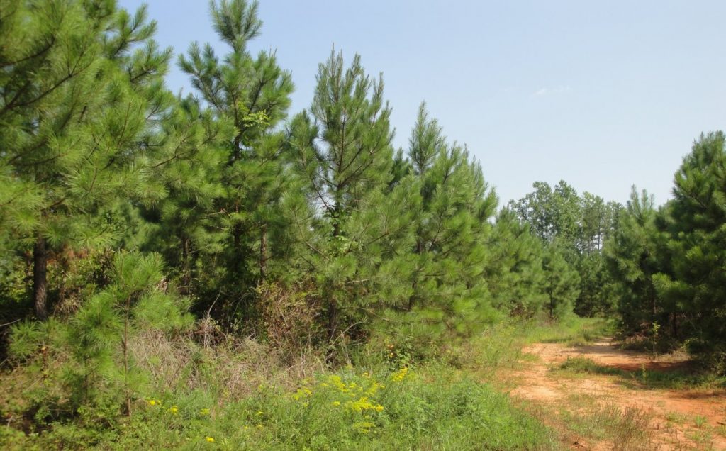
After church, we went to a nice Italian, simple Italian restaurant on the main street in Roanoke Rapids. It is a pleasant little down, but not really exciting. This is probably the place where my thinned trees will end up.Below you can see the trees on the Freeman place, planted in 1996 and ready to be thinned.
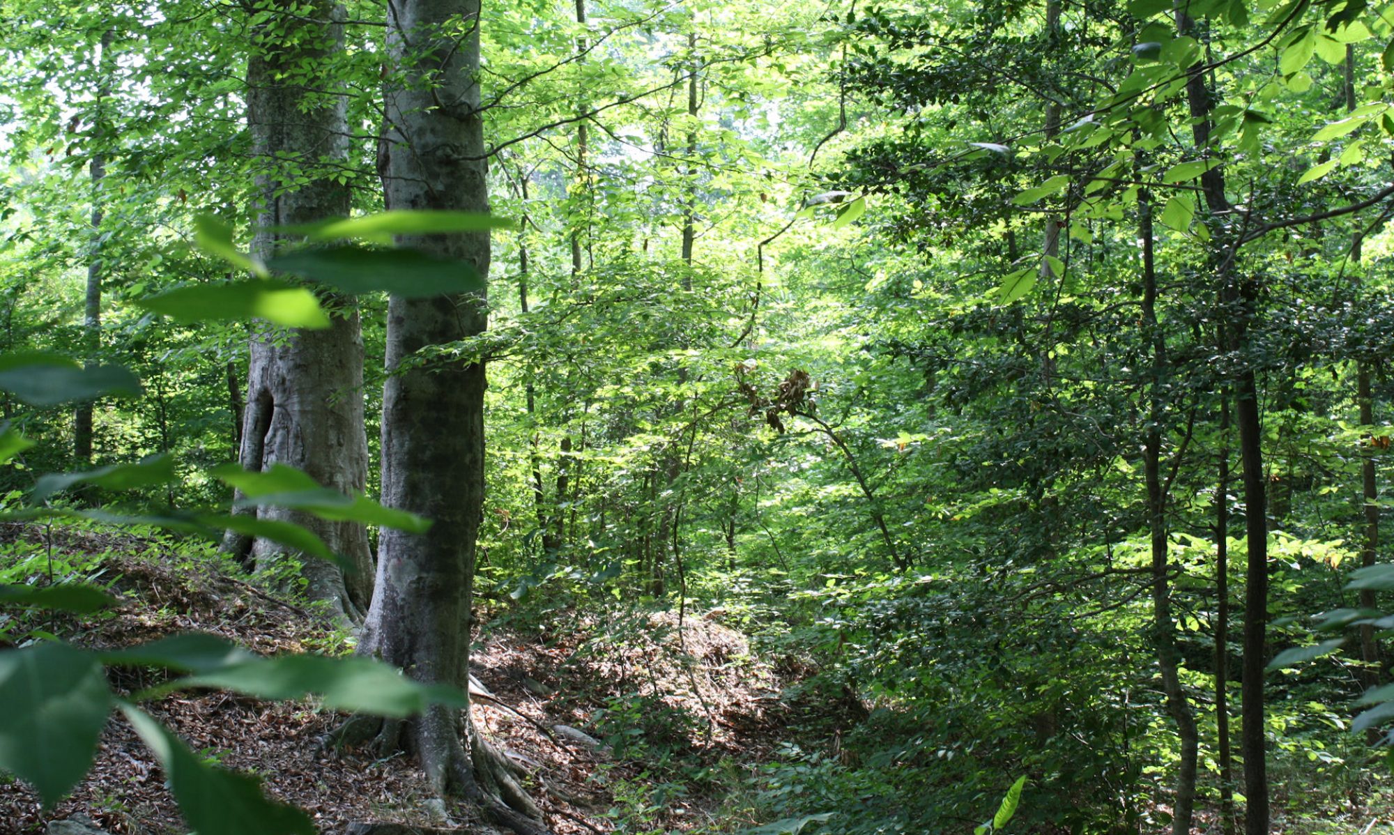
We were down in the southern part of the state so that Mariza and Chris could see the forests. Mariza had never seen the Freeman place and had not seen the CP property recently. Things have changed a lot. It was good to be able to show them the trees and explain a little about forestry. Some of these trees will belong to Mariza someday. It is good if she gets to know the land and can become a good steward of the nature on it.
I got to ride down and back with Mariza, which was good. We had a chance to talk a little. I don’t see Mariza that much anymore. We used to take walks and talk when she was a little girl, but since then not so much. It gets harder to keep in touch when they move away. She has become a wonderful young woman and I want to get to know her better. Above shows Mariza and Chris in one of our wildlife clearings in front of the CP pines, planted in 2004. The picture below is Mariza and me (I think she is just a little taller than I am). Right underneath is a picture from around the same place in 2006. I always like to show the contrast, which each year gets more pronounced. It was not that long ago, but already the difference is remarkable. Below that are Mariza and Chris walking among the mature pines at the edge of the property.
There was a lot of activity on the farms. On both places, guys from the hunt clubs were exercising and training their hunting dogs. The guy on the Freeman property was going to run down some coyotes. I don’t think he was hunting the coyotes when we saw him, just training the dogs. You can hunt coyotes all year around on private land in Virginia. I have no problem with coyotes either way, but if somebody from the hunt club wants to chase them on my land, I don’t have a problem with that either. Coyotes are not native to Virginia and they are a nuisance to local farmers.
The guys on CP were training their dogs for rabbit hunting, which starts next week.
We are getting more and more bear in the area and I am not enthusiastic about that. I know bears are mostly harmless, but the “mostly” part worries me a little. I bring my lunch with me when I work on the land and I am often there alone. I really don’t want to have to think about attracting bears or not. Southside Virginia was not “bear country for more than a century, but now they are back. We sometimes see bear signs and people have taken pictures with those motion activated cameras.
Of course, absolute proof of bears is that a local guy killed one with a bow and arrow. I would be a little nervous going after a bear with a bow and arrow. It just doesn’t seem like that is “loaded for bear,” but I guess that some of those new bows are really effective. I am glad that the hunters go after the bear. I want them to retain their fear of humans. In different seasons, it is legal to hunt bear with bow, black powder and ordinary firearms. Dogs can be used to hunt bear in some situations. Brunswick County has a bear hound training season, where hunter can train their dogs to chase bear, but cannot kill them if they chase them down.
Hunting and trapping regulations are available at this link.Below is Genito Creek. I like to go down there, since it is quiet and ever changing. I explained to Mariza and Chris how the creek keeps on moving as it undercuts one bank and then the other. It floods an area of at least fifty yards on both sides. This is the kind of place that someone would like to have a house or a cabin because it is pretty and pleasant. Of course, this is also the kind of place where nobody should build a house, since it will regularly flood.
I made an unexpected trip to the farms yesterday. I wanted to look at a piece of land near the Nottoway River. FM wants to buy the timber and wants me to buy the land. In other words, he gets the wood; I get land to grow new trees. It is a long-term proposition for me. I couldn’t even thin until around 2025. On the other hand, I can get the land cheaper and grow the trees later.
The land would not be only for forestry. There is a lot of road frontage and the property is across from the Nottoway River, which you see in the picture. (It was a very foggy morning, as you can see and chilly. It later got hot and humid.) They would leave the trees near the streams etc, so it would remain wooded and attractive. There is a public boat launching place across from one corner of the property. It was a very foggy morning, as you can see and chilly. It later got hot and humid. Under the right conditions, I could sell off some lots right at the corner with the river, where people could build “farmettes” or cabins. I have no idea how that works, but I bet I can figure it out. That would help pay for the land.
Land is inexpensive these days because of the recession. It won’t stay that way forever and this may be a good time to buy. But the timing is always tricky and I don’t have that kind of money to just risk. The forest land and its produce will essentially fund large chunks of my retirement, or not. In a rational market, this land would become more valuable. Markets are always rational … in the long run. But as John Maynard Keynes said, “Markets can remain irrational a lot longer than you and I can remain solvent.”
Anybody want to come in on a forestry investment? Or maybe buy a beautiful home site near an officially designative senic river? Well, I have to figure out the finances. I really just don’t know.
Pictures
The first picture shows the boat landing on the Nottoway River. The picture under that is the part of the property I was looking at that was cut in 2001. This is natural regeneration and would remain on the land. I would have to mange it a little, but the trees look healthy. As comparison, you can see my trees on the CP property (same day. The sun came out.) They are only six years old (planted 2004) but they are bigger by a couple feet and fuller because of better genetic stock and some management. The second lastpicture shows the pines on our Freeman property. They were planted in 1996 and will be thinned later this month (first thining). They need thinning. Light will reach the ground and it will be better for wildlife. The last picture is a dog that just wandered by. He has a tracking collar, so he is probably a hunting dog. I offered him a piece of ham from my sandwich. He took it but remained a little spooked.
I went down to the farms yesterday and did some spraying, chopping and rock moving. Above is the baldcypress in our wet area.
On the plus side, the road that the utility company repaired along their right-of-way has settled nicely and their plantings are growing vigorously. I also saw a lot of quail and almost a dozen wild turkeys. I tried to sneak up on them, but they flew off. I think they have good eyesight.
I sprayed down some resurgent tree-of-heaven, many of the vines and some of the hardwoods mixing in with my pines. It was really hot and not very pleasant work. I got a four gallon backpack sprayer, which makes it easier to do the work, but it is heavy. Today I have a stiff neck from reaching and spraying while carrying that thing on my back. The good news is that I found a product that keeps off and actually kills ticks. It is called “Repel.” You can apply it to your boots and clothes. It irritates the skin, so it is good only for heavy duty tick killing, not casual mosquito avoidance. I pushed brush all day and picked up no ticks or chiggers, so the stuff works.
One interesting thing I heard at the local gas station in Freeman is that there may be plans to open a wood pellet (the kind they use for heating) plant near Jarratt, VA. This would be a good development, since it is near my forests and would provide a market for thinned trees and pulpwood. Maybe the prices will go up a little. They are abysmal now, so it cannot hurt.
Making small wood into pellets for home heating is a better idea than trying to turn it into liquid fuel like ethanol, which takes as much energy as it produces. You are usually better off being as simple as possible.
I bought a couple gallons of Chopper Gen2 and some backpack sprayers. The boys and I went down to the forests to check up on them and spray down some of the vines. I have mixed feelings about spraying. I would spray the whole place if I was really doing intense pine management. They usually do this with helicopters and it would cost me around $6000. I don’t like to spend the money and I don’t like to spray everything. I want some diversity, but the vines are getting out of hand. The backpack sprayers allow more precise applications and they cost much less. The materials cost a couple hundred dollars and labor is cheap, essentially free. Getting the boys involved with the land is also a good idea. So that is what we did.
We got an early start, but only worked until about noon. It was getting too hot and I didn’t want to kill the boys or make them not like the forest. We got the easy targets, i.e. the places within easy reach of the roads and paths. I like to do these things in iterative ways. This will give me a chance to see how it works and decide if I want to do it more widely. It will also give me something useful to do on my visits. I can spray down some of the offending vines each time I go down and do it selectively.
I talked to Larry and Dale Walker from the hunt club. They also work at a forestry company and showed me their operation last year. You can see pictures and read about that here and here. They are honest guys and their firm does a good job. We talked about thinning on the Freeman property. It would be good to do it this fall. This would be my first significant harvest and I look forward to it.
The utility company put in new poles. They ripped up the dirt a lot, but have since leveled it out and reseeded it. The grass is coming up. The wires and the right-of-way are useful, despite the fact that they take up eight acres of my land. The opening provides good wildlife habitat and the long, narrow aspect produces a lot of the “forest edge” so favored in wild ecology. From the practical point of view, the most useful thing about the right-of-way is the road. The electric company maintains the road and they just finished fixing it up. It was really rutted before, but they put in rocks over the washouts and made little stone banks to divert the storm water. All this will provide good infrastructure for the thinning operation. If for what they did, I would have to do it and/or the timber companies would have to do it and that would cut into what they could pay me for the wood. It is a de-facto subsidy for me.
The pictures are from the farms. You can see the roads along the right-of-way. The picture of Alex and Espen shows the grassy path Larry Walker made down to the creek. It is a “wildlife corridor” Alex is looking very buff these days. They are hard workers and strong boys. They can get a lot more done than I can. My clover fields are looking good. Other wild plants are beginning to seed in and this is okay.
It was a little early to go down to the farms. The trees haven’t quite started to grow yet and the clover is still small and not flowering. I will be back in a few weeks. But I wanted to check on flood damage now. Above are the trees near the clover field at the top of the hill. The truck gives perspective. The land was clear cut in 2003, so you can see how much the trees have grown since then. The biosolids helped them grow faster last year. Below is another truck comparison. There is an interesting detail. Look at the two trees behind the truck. The round top one is a “volunteer” i.e. natural regeneration. It was probably a little tree when the place was cut. The one next to it is a planted genetically “super tree.” Because of their location at the crossroad, I have been paying attention to this place. The round top tree was twice as big as the ones around it when I first noticed. Today, you can see that the one next to it is a little bigger and I expect that after this growing season it will be significantly bigger. I will take another picture.
I saw clear evidence of heavy rain and lots of runoff, but no real damage. The places near the streams overflowed, but that doesn’t hurt the trees. The water is running UNDER one of the water pipes. I figure it will undercut the road, but I don’t think there is much to do about it. I will put in a load of rocks and turn it into a ford when/if it collapses. I think it will be better for the water to run over instead of under.
One of the little streams changed course last year. It went back to its older course. When I dig down, I find sand and gravel all over, indicating that the stream has changed course a lot. It creates wetlands until the mud piles up into natural levies, and then it moves again. You can see from the picture above that there have been times when the ground was dry for a long time. The dead trees were alive when I got the place in 2005, when the stream shifted and evidently drown the roots in wetland. I suppose that now the stream has shifted again, it will be dryer, although the whole place is spongy.
I also think that runoff will decrease over time as the trees on the slopes get bigger and their roots absorb more of the water before it hits the streams.
I want to get the trees on the Freeman tract thinned this year or next, before I get to Brazil. Above you can see from the comparison with the truck that the trees are big enough and thick enough. They will be fourteen years old this year, which is a little early for thinning but within the range. Below is the power line right-of-way. They replaced the wooden pylons with steel and kind of tore up the grass. I have eight acres under those things. I am looking into establishing quail habitat, since I cannot plant trees (or allow them to grow) that would interfere with the wires. On the plus side, it provides a long area of forest edge and wildlife plot and the utility company maintains the road.
It has been cold again this year but this year we are also getting more snow. They got a lot of snow in southern Virginia & North Carolina, so I wanted to go down and look at the snow on the farm. Well, it wasn’t a lot of snow by Wisconsin standards and it will melt in a few days, but there was more than usual and it created a different look for the place. You really wouldn’t guess that you were looking at southern Virginia.
I saw a couple cars in the ditch on the way down and I didn’t dare take the back roads, as I usually do. Instead I went down I95 all the way down to Emporia and then went over on 58. I also didn’t dare drive down the dirt roads on the farm. You can see that 623 was good in the spot above, but look near the bottom and you can see why I didn’t want to drive up the farm road. It is harder to walk through the snow but it is nice to feel it underfoot. There were a few animal track, but it was otherwise undisturbed. It is nice to have land.
It was a long trip to see it and it took longer because of the adverse weather conditions. I finished almost the entire audio-book Infotopia, which I found very interesting and useful (I hope) in my job. This was one of the three audio downloads on Audible.com that Mariza gave me for Christmas. It was a good gift. Audio books make long drives bearable and even beneficial. I lose my NPR a few miles outside Washington. I don’t like music radio or those silly talk shows that purport to give advice that will solve problems that I don’t have. Audio books do the job.
Another good audio program is “the Teaching Company”. Alex likes them too because they are around forty-five minutes long, which fits his workout schedule.
I talked about my flight over the farms with Brian in my last post. The aerial perspective was fun. I could see the interrelations of the wildlife plots for the first time. Below are some pictures with comments.
Above is a panorama of the feed plots and a picture of almost the whole CP farm (the wing covers only a small corner.) You can see how they are connected and how form openings in the woods. They are mostly covered in clover, which appears a lighter green this time of year. The picture below shows the sun reflecting off the streams. It has been a wet year, so they are wider than usual. I was a little surprised how much water is spread over the wetland area near the center of the photo. BTW, the gray trees are the broad-leaf forest, currently bare of leaves, around the streams and boundaries, so you can see things clearer this time of the year than when everything is green.
Below is the Freeman tract. You can see the boundaries with the deciduous bare branches. It is roughly rectangular. You can see the Vulcan quarry off to the NW. It is much closer to our property than I thought. You have to drive a long way around to get to the farm gate. As I wrote in yesterday’s post, that quarry may eventually become a deep lake, which would be a nice addition. The utility lines that run through the property were recently upgraded, and the dirt was a bit torn up by the machines. I have a total of eight acres under those lines, so it is not inconsequential. I would like to plant this over in warm season native grasses and encourage some quail habitat. The long narrow aspect provides a lot of edge environment.
The Freeman trees will be fourteen years old this year. It is an exceptionally good stand and I think they will be ready for thinning, maybe even this year. I have spent a lot less time on this tract. The CP farm was my first one, so I spent a lot of time there just getting to know forestry, it is also more interesting because it has a greater variety of environments, including the wetlands and hills. You cannot really tell from the pictures, but CP is a lot hillier than Freeman. But Freeman is more valuable for growing trees, acre for acre. Less interesting is often more valuable.
Above is a panorama showing the local lay of the land. My forest is only part of the bigger picture. The whole area looks like this. You can see how important forestry is to southern Virginia. Flying over made that clear. It is not just covered in forest, but also lots of clearly managed forests. BTW, the distortion you see in the picture is just the reflections from the window glass.
Brian (that is him above) has a plane and knows how to fly, so I got a chance to see the tree farms from the air. This is something I have long wanted to do. I can get the pictures from Google earth, but they are not completely up to date, give only one angle and are just not the same as a live view. I will included some pictures I took in the next post. They are a little hazy because I took them through the glass of the windows.
Above is take off and below is landing.
I have never flown so low over places I knew so well. We left from Leesburg Airport. All the little planes are lined up and it is amazingly informal. Flying out around Washington is highly regulated, but once you get outside the security zones, you can fly were you want. We had GPS, but actually found the farms by looking for landmarks on the ground. It is more fun that way.
You notice a few things from the air that are less clearly evident to the terrestrially tied road denizens. There is a lot more empty space than we think. Most of our structures are near the roads, but roads make up only a small amount of the countryside. On the other hand, lots of very nice houses are hidden down long paths, away from the main roads, obscured by trees or topography. This seemed to be especially true in Loudon County. Of course, my sample was skewed since I took off and landed there, but Loudon County is a classic wealthy exurban area, so I think this kind of settlement is indeed more common there.
Another thing I noticed was the large numbers of ponds and impounded water. Natural lakes and ponds not associated with meandering river are uncommon south of the Mason-Dixon Line because they are largely gouged out by glaciers and the most recent glaciations didn’t get that far south. But people like lakes and they have created lots of them were they didn’t exist before. You can tell the ponds because they tend to have at least one straight side from the dam that holds back the water. Larger impounds have very irregular banks. Water wears away the jagged banks over time, but not enough time has passed for these man-made bodies of water.
Below is Vulcan Quarry near Freeman. That is where my rip-rap comes from. The material is porphyritic granite. I am not sure exactly the significance of that, but the rock is kind of grayish with crystals and twenty tons of rip-rap cost around $500, delivered. It is good to have land near the source. In time, I suppose that quarry could become a fairly deep lake. Since it in not far from the Freeman forest tract, we may eventually have lakefront property.
Neither man-made nor natural lakes last very long in the great scheme of geological time, since they silt up. Man-made lakes tend to silt up faster because they are often or river fed and they impound muddy floodwaters.