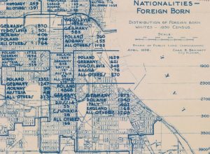
When you drive through the older parts of Milwaukee, you might notice the large number of churches or former churches. The reason is partly explained by this map, if you understand the underlying culture(s).
Milwaukee, like many Midwestern cities, had lots of foreign born citizens. In those days, nationality was a lot like race is today. Each group felt different and usually superior to those others around them.
Their children and grandchildren would intermarry and forget their nationalities except for some food preferences and t-shirts saying something like “kiss me, I’m …”, but back then, as my father told me, a lone Polish kid could get harassed if he wandered into a group of Serbians and the Polish “gang” would return the favor when the situation was reversed.
Religion was a big part of cultural heritage and so each nationality built its own church, sometimes only a short distance from the others. My grandparents were proudly Polish Catholic. Despite their poverty, they invested in sending my father and his brothers to Catholic school at Saint Stanislaus and made of special point of getting a house within easy walking distance of the church and school.
You cannot tell how close it was if you go there today. They build the I-94 freeway through the old Polish neighborhood, putting a river of concrete between my grandparent’s house and their beloved church.
Freeway construction and urban renewal had the (maybe) unintended outcome of hastening the breakdown of the old ethnicity, the remnants of which we can now see in nice bars and restaurants occupying the extant old buildings.
One of the reasons I still like to visit and walk around my native city is that I can appreciate the layers of history, seeing what is still there and imagining what is gone but still leaves its social and cultural shadow.

